Kolkata, April 18 -- The Irrigation and Waterways (I&W) department is planning to undertake hydrographic, bathymetric and topographic surveys of the rivers, canals, reservoirs and hydraulic structures in a bid to support its planning and designing activities for development works.
An I&W department official confirmed that an expression of interest has been floated to create a panel of qualified survey agencies with advanced expertise in conducting the said types of surveys. This will help in designing canals and waterways to mitigate waterlogging, planning embankments, riverbank protection and hydraulic structures. It will also conduct reservoir sediment surveys and other water resource management tasks.
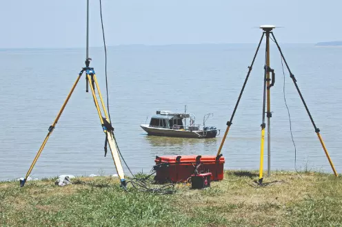
The entire survey is divided into three kinds of high-quality data collection. The hydrographic data collection will involve measuring river discharge, stream flow velocity and tide/river gauge levels, collection of river water samples, preparing and submitting drawings and reports.
Such data will be used for understanding river dynamics and planning hydraulic interventions.
Bathymetric data collection (water-based survey) will involve surveying of cross-sectional profiles and bed profiles of rivers, canals, reservoirs and water bodies with water depth exceeding one metre. It will also involve conducting levelling and contour surveys, establishing Ground Control Points (GCPs) and Great Trigonometrical Survey (GTS) benchmarks. Based on these, drawings and reports will be submitted. The official said that such data is essential for reservoir management, riverbed profiling and flood control planning.
The topographic data collection (land-based survey) will involve surveying topographical and cross-sectional profiles of riverbanks, embankments and hydraulic structures. Such data will be applicable for embankment design, land-use planning and infrastructure development, it was learnt.
The selected agency will have to adhere to Survey of India guidelines and standard operating procedures. It will conduct the satellite-based surveys between 8 am and 2 pm.
The I&W department will identify survey areas and arrange permissions for surveying in restricted areas, conduct performance reviews and cross-verify data. The department will monitor daily, with quarterly performance reviews by the executive engineer.
The empanelment process, if executed effectively, will enhance the I&W department's capacity to manage water resources and infrastructure projects, contributing to sustainable development in West Bengal, said the official.
Published by HT Digital Content Services with permission from Millennium Post.